An 8,000-meter expedition in Nepal typically refers to climbing one of the country's high-altitude peaks, all of which rise above 8,000 meters (26,247 feet). These mountains are among the highest in the world and include some of the most famous and challenging climbs. In Nepal, there are 14 peaks over 8,000 meters, and many climbers visit the country to attempt to summit these giants. Here’s an overview of some of the key 8,000-meter peaks in Nepal:
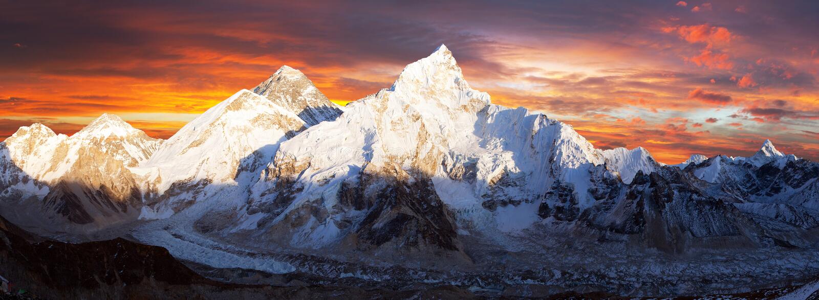
1. Mount Everest (8,848.86 meters / 29,031.7 feet)
- The world’s highest peak, Everest attracts the most climbers and is located in the Khumbu region of Nepal.
- Popular starting point: Base Camp is the usual access point, and from there, climbers make their way through the difficult sections like the Khumbu Icefall, Lhotse Face, and Hillary Step.
2. Kanchenjunga (8,586 meters / 28,169 feet)
- The third-highest mountain in the world, Kanchenjunga lies on the border between Nepal and India.
- It’s known for its beautiful, challenging terrain and fewer crowds compared to Everest.
3. Lhotse (8,516 meters / 27,939 feet)
- Lhotse is located near Everest and shares part of the same route.
- It is the fourth-highest peak in the world, with a steep and technical ascent.
4. Makalu (8,485 meters / 27,838 feet)
- Makalu is known for its challenging, steep climbing routes, and it’s less crowded than Everest or Lhotse.
- It is considered one of the hardest mountains to summit due to its technical nature.
5. Cho Oyu (8,188 meters / 26,864 feet)
- The sixth-highest peak in the world, Cho Oyu is one of the most popular 8,000-meter mountains for climbers due to its relatively accessible route.
- Located near the Tibet-Nepal border, it is a favorite among climbers who want to experience high-altitude mountaineering.
6. Dhaulagiri (8,167 meters / 26,795 feet)
- Located in the western part of Nepal, Dhaulagiri is known for its remote location and difficult approach, making it less visited by climbers.
7. Manaslu (8,163 meters / 26,781 feet)
- The eighth-highest mountain in the world, Manaslu is popular for its challenging climb, especially its steep ridges and avalanche-prone slopes.
- The trekking route around Manaslu is also becoming more popular.
8. Annapurna I (8,091 meters / 26,545 feet)
- Annapurna I has one of the highest fatality rates of any 8,000-meter mountain.
- The south face is particularly difficult to climb, and it's known for technical challenges like steep ice and rock climbing.
Expedition Challenges
- High-altitude Mountaineering: These expeditions are physically demanding and require technical climbing skills, stamina, and the ability to adapt to extreme altitudes.
- Acclimatization: Due to the extreme altitude, climbers must spend time at various camps to acclimatize and avoid altitude sickness.
- Weather and Conditions: Weather can be unpredictable, with harsh winds, snowstorms, and temperatures dropping well below freezing.
Preparation for the Expedition
1. Physical Fitness: Climbers should prepare with a focus on endurance, strength, and high-altitude training.
2. Technical Skills: Skills in ice climbing, rock climbing, and crevasse rescue are necessary.
3. Logistics and Support: Most climbers hire local guides, Sherpas, and support teams for the trek and summit attempt.
4. Permits: An expedition permit is required for climbs over 6,500 meters, and the government requires a climbing permit for peaks above 8,000 meters.
5. Equipment: Specialized equipment is needed, including crampons, ice axes, ropes, high-altitude clothing, and oxygen bottles (for summits over 8,000 meters).
The Role of Sherpas
- Sherpas are a vital part of any high-altitude expedition. They assist with carrying loads, setting up base camps, and guiding climbers through dangerous terrain.
- Many climbers rely on Sherpas to help with the summit push, providing both logistical and physical support.
Mt Everest 8848 m (Normal Route)
An 8,000-meter expedition in Nepal typically refers to climbing one of the country's high-altitude peaks, all of which rise above 8,000 meters (26,247 feet). These mountains are among the highest in the world and include some of the most famous and challenging climbs. In Nepal, there are 14 peaks over 8,000 meters, and many climbers visit the country to attempt to summit these giants.
Here’s an overview of some of the key 8,000-meter peaks in Nepal:
1. Mount Everest (8,848.86 meters / 29,031.7 feet)
- The world’s highest peak, Everest attracts the most climbers and is located in the Khumbu region of Nepal.
- Popular starting point: Base Camp is the usual access point, and from there, climbers make their way through the difficult sections like the Khumbu Icefall, Lhotse Face, and Hillary Step.
2. Kanchenjunga (8,586 meters / 28,169 feet)
- The third-highest mountain in the world, Kanchenjunga lies on the border between Nepal and India.
- It’s known for its beautiful, challenging terrain and fewer crowds compared to Everest.
3. Lhotse (8,516 meters / 27,939 feet)
- Lhotse is located near Everest and shares part of the same route.
- It is the fourth-highest peak in the world, with a steep and technical ascent.
4. Makalu (8,485 meters / 27,838 feet)
- Makalu is known for its challenging, steep climbing routes, and it’s less crowded than Everest or Lhotse.
- It is considered one of the hardest mountains to summit due to its technical nature.
5. Cho Oyu (8,188 meters / 26,864 feet)
- The sixth-highest peak in the world, Cho Oyu is one of the most popular 8,000-meter mountains for climbers due to its relatively accessible route.
- Located near the Tibet-Nepal border, it is a favorite among climbers who want to experience high-altitude mountaineering.
6. Dhaulagiri (8,167 meters / 26,795 feet)
- Located in the western part of Nepal, Dhaulagiri is known for its remote location and difficult approach, making it less visited by climbers.
7. Manaslu (8,163 meters / 26,781 feet)
- The eighth-highest mountain in the world, Manaslu is popular for its challenging climb, especially its steep ridges and avalanche-prone slopes.
- The trekking route around Manaslu is also becoming more popular.
8. Annapurna I (8,091 meters / 26,545 feet)
- Annapurna I has one of the highest fatality rates of any 8,000-meter mountain.
- The south face is particularly difficult to climb, and it's known for technical challenges like steep ice and rock climbing.
Expedition Challenges
- High-altitude Mountaineering: These expeditions are physically demanding and require technical climbing skills, stamina, and the ability to adapt to extreme altitudes.
- Acclimatization: Due to the extreme altitude, climbers must spend time at various camps to acclimatize and avoid altitude sickness.
- Weather and Conditions: Weather can be unpredictable, with harsh winds, snowstorms, and temperatures dropping well below freezing.
Preparation for the Expedition
1. Physical Fitness: Climbers should prepare with a focus on endurance, strength, and high-altitude training.
2. Technical Skills: Skills in ice climbing, rock climbing, and crevasse rescue are necessary.
3. Logistics and Support: Most climbers hire local guides, Sherpas, and support teams for the trek and summit attempt.
4. Permits: An expedition permit is required for climbs over 6,500 meters, and the government requires a climbing permit for peaks above 8,000 meters.
5. Equipment: Specialized equipment is needed, including crampons, ice axes, ropes, high-altitude clothing, and oxygen bottles (for summits over 8,000 meters).
The Role of Sherpas
- Sherpas are a vital part of any high-altitude expedition. They assist with carrying loads, setting up base camps, and guiding climbers through dangerous terrain.
- Many climbers rely on Sherpas to help with the summit push, providing both logistical and physical support.
Mt Everest 8848 m (Normal Route)
Climbing Mount Everest (8,848.86 meters / 29,031.7 feet) via the Normal Route is the most common and popular approach for summit attempts. The Normal Route typically follows the South Col Route from the southern side of the mountain in Nepal, and climbers begin their journey from Everest Base Camp (EBC), situated at 5,364 meters (17,598 feet). Here’s a detailed overview of the Normal Route, its stages, and key points to consider:
Key Stages of the Normal Route
1. Everest Base Camp (EBC) – 5,364 meters (17,598 feet)
- Starting point: After trekking to Base Camp, which usually takes 8-12 days depending on the pace and acclimatization, climbers prepare for their ascent.
- Trekking to EBC: Most climbers trek from Lukla, passing through villages like Namche Bazaar and Tengboche, to reach Everest Base Camp.
- Acclimatization: Proper acclimatization is critical to avoid altitude sickness. Climbers spend several days at Base Camp to acclimatize and rest.
2. Camp 1 – 6,065 meters (19,900 feet)
- From Base Camp, climbers ascend the Khumbu Icefall, a glacier with large crevasses and towering ice seracs, which can be dangerous.
- The Icefall is one of the most treacherous parts of the climb due to falling ice and avalanches. It’s usually crossed in the early morning for safety reasons.
- After the Icefall, climbers reach Camp 1, which is located on the Western Cwm, a flat, glaciated valley surrounded by massive mountains.
3. Camp 2 – 6,400 meters (21,000 feet)
- After crossing the Western Cwm, climbers move up to Camp 2, which is located at the base of the Lhotse Face.
- This is another acclimatization stop. The ascent to Camp 2 is demanding, but it is considered relatively straightforward compared to the Icefall.
4. Camp 3 – 7,200 meters (23,622 feet)
- From Camp 2, climbers ascend the Lhotse Face, a steep section of the climb. Fixed ropes are placed to assist climbers in navigating the icy and rocky face.
- This part of the climb can be challenging, and climbers often spend time at Camp 3 to rest and acclimatize before pushing higher.
5. Camp 4 – 7,920 meters (26,000 feet) (South Col)
- Camp 4 is located at the South Col, a saddle between Mount Everest and Lhotse.
- This is the highest point on the Normal Route that climbers spend the night before attempting the summit.
- It is an exposed camp with minimal shelter, and temperatures can drop extremely low. Climbers typically rest here to gather strength for the final push to the summit.
6. Summit Push – 8,848.86 meters (29,031.7 feet)
- The summit push typically begins in the early hours of the morning from Camp 4. Climbers ascend through the Hillary Step, a rocky outcrop just below the summit that presents a technical challenge, though it is often assisted by fixed ropes.
- From here, it’s a long, exhausting climb to the summit, typically around 8-12 hours of continuous ascent.
- The summit provides a breathtaking panoramic view of the Himalayas, but it’s a brief stop due to extreme weather conditions and the risk of altitude sickness.
Additional Challenges and Considerations
1. Altitude and Acclimatization
- Everest's high altitude (over 8,000 meters) makes acclimatization essential. This process allows the body to adjust to lower oxygen levels.
- Climbers often follow a strategy called "climb high, sleep low": ascending to higher camps during the day and returning to lower camps to sleep.
2. Weather
- The weather on Everest is highly unpredictable, with strong winds, low temperatures, and snowstorms. The summit window is typically in May, before the monsoon season begins.
- Climbers must plan their summit push around weather forecasts.
3. Oxygen Use
- Most climbers use supplemental oxygen starting from Camp 3 or Camp 4, as the oxygen levels are extremely low above 8,000 meters.
- Some climbers opt to climb without supplemental oxygen, but this is much more challenging and dangerous.
4. Logistical Support and Sherpas
- Everest expeditions require a lot of logistical support. Many climbers rely on Sherpas for guidance, carrying supplies, and fixing ropes along the route.
- Sherpas are invaluable for their expertise in navigating the mountain, setting up camps, and assisting with technical climbing.
5. Dangerous Sections
- Khumbu Icefall: The first section of the climb is notorious for its constantly shifting ice and crevasses.
- Lhotse Face: A long, steep, and icy ascent with fixed ropes.
- Hillary Step: A technical section just below the summit that requires climbing skills.
- The final push to the summit is a long, exhausting, and risky endeavor, especially in the "death zone" (above 8,000 meters), where the body starts to deteriorate due to lack of oxygen.
Timing of the Expedition
- The best time to attempt the summit is during the spring season (April to early June) when the weather is typically more stable. The monsoon season (June to September) brings heavy snow, making climbing conditions dangerous.
- Climbing expeditions can take around 2 months, with several weeks spent on acclimatization and waiting for the optimal weather window.
Mt. Everest 8848 m (Other Route)
In addition to the Normal Route via the South Col, Mount Everest has several other climbing routes, each with its own set of challenges. These routes are less commonly used, and often more technical or dangerous, requiring a high level of mountaineering expertise. Below are the notable alternative routes on Mount Everest:
1. North Col Route (Tibetan Route)
- Starting Point: This route begins from Tibet, on the northern side of Everest. The starting point is Tibetan Base Camp (also called Base Camp North), located at around 5,150 meters (16,896 feet), and climbers typically approach from Tibet through China.
Key Features:
- The ascent involves climbing through the North Col, a saddle between Everest and the neighboring Changtse peak.
- The North Col is less technically difficult than the South Col route but still presents challenges, such as ice and rock climbing on the North Face.
- The route involves navigating through steep, rocky sections and glaciers.
Challenges:
- The North Face of Everest is known for its exposed, steep terrain, particularly near the First Step, a rocky outcrop that requires a short but difficult rock climb.
- Weather and winds can be harsher on the northern side, with colder temperatures and stronger winds.
- The climb to the summit from the North Col involves fewer technical sections compared to the South Col but remains physically demanding.
2. West Ridge Route
- Starting Point: The West Ridge Route starts from Everest Base Camp (South) in Nepal, similar to the Normal Route, but climbers then ascend the West Ridge after reaching Camp 2.
Key Features:
- The West Ridge provides a less crowded route to the summit compared to the Normal Route.
- This route requires technical climbing on steep rock and mixed ice and rock sections.
- The West Ridge joins the South Col Route just below the summit.
• Challenges:
o The West Ridge is a highly technical route and demands significant rock climbing, ice climbing, and endurance.
o The Pyramid Peak is a key section on this route, requiring careful navigation.
o Due to the technical nature, this route is less popular and attracts more experienced climbers.
3. Southwest Face Route
• Starting Point: Like the Normal Route, climbers approach from Everest Base Camp on the southern side in Nepal.
• Key Features:
o The Southwest Face is a challenging, direct route to the summit, first successfully climbed in 1975.
o This route avoids the Khumbu Icefall and the Lhotse Face.
o Climbers ascend steep rock and mixed ice, with sections that can be highly technical and challenging in terms of route finding.
• Challenges:
o The Southwest Face has significant rock climbing challenges, including steep rock faces and difficult ice conditions.
o The climb is known for its exposure and risk of rockfall, especially as climbers approach higher altitudes.
o Due to the technical nature, it requires climbers with a high skill level in mixed climbing (rock and ice).
4. Northeast Ridge Route
• Starting Point: This route also begins from Tibetan Base Camp (on the northern side in Tibet).
• Key Features:
o The Northeast Ridge route is one of the classic routes on the north face of Mount Everest.
o It is considered a difficult and long climb that involves rock and ice climbing.
o The route features the First Step and Second Step, both of which are difficult rock faces that require skill in climbing.
• Challenges:
o The First Step is a vertical rock wall that climbers need to ascend using fixed ropes. The Second Step is another steep section, though less technical than the first.
o Climbers may face extreme cold, high winds, and significant altitude issues.
o The final push from the summit ridge can be exhausting due to high altitude and lack of oxygen.
5. Southeast Ridge (via the Lhotse Face)
• Starting Point: The Southeast Ridge is often combined with the South Col Route, but it provides a more challenging alternative for those attempting the summit from the south side of Everest.
• Key Features:
o The Southeast Ridge is part of the standard Normal Route, but the approach up this ridge offers an alternative to the direct South Col route.
o The climb includes sections on the Lhotse Face, a steep icy slope, with the addition of fixed ropes for safety.
• Challenges:
o The Lhotse Face is notoriously steep and physically demanding, with numerous sections of ice and snow.
o The climb is long and requires proper acclimatization and careful management of oxygen supplies.
o The Hillary Step is a significant technical feature near the summit, demanding careful rock climbing skills.
6. The Direct East Face Route (Rare)
• Starting Point: This route is a direct ascent of the East Face of Everest, which is rarely used due to its extreme technical difficulty and danger.
• Key Features:
o This route is one of the hardest and most dangerous on Everest.
o The East Face is steep, covered with mixed ice, rock, and snow, requiring advanced climbing skills and the ability to handle serious alpine terrain.
• Challenges:
o This route has a very low success rate and has only been climbed by a few elite mountaineers.
o The climb involves steep rock climbing, and climbers have to contend with the threat of rockfall and avalanches.
o Because of its severity, the East Face route is often considered impractical for most climbers attempting to summit Everest.
Considerations for Choosing Alternative Routes
• Climbing Experience: Some of these routes, such as the West Ridge or Southwest Face, are more technically demanding than the Normal Route, requiring significant rock and ice climbing skills.
• Weather: The northern side of Everest (especially from Tibet) can be colder and windier, making climbs from that side more dangerous and less popular.
• Traffic and Crowds: While the South Col route is the most popular, routes like the West Ridge and Southwest Face are less crowded, allowing for a more solitary experience, though they come with more technical challenges.
Mt. Kanchenjunga 8586 m
Climbing Mount Kanchenjunga (8,586 meters / 28,169 feet) is a significant and challenging mountaineering expedition. The world’s third-highest mountain, Kanchenjunga is located on the border between Nepal and India, and it is known for its remote location, difficult access, and technical routes. Due to its elevation, it is a coveted peak for experienced climbers who seek a more isolated and less crowded alternative to the more frequently climbed mountains like Mount Everest or K2.
Overview of the Kanchenjunga Expedition
Climbers can approach Kanchenjunga from the south (Nepal) or north (India), but most expeditions opt for the southern approach, which is more popular due to its access from Nepal.
Here’s a detailed overview of what an expedition to Kanchenjunga entails:
1. The Routes on Kanchenjunga
The two primary routes are the South Route and the North Route, with the South Route being the most common.
South Route (Nepal Side):
• Base Camp: The trek starts at Kanchenjunga Base Camp (5,143 meters / 16,877 feet), located on the south side of the mountain in Nepal. It is accessed by a multi-day trek that starts from the town of Suketar or Taplejung, which is around 8 to 10 days away from Base Camp.
• Climbing Route: The South Route is characterized by a series of steep ridges and glaciers. The route takes climbers through a mix of snow, ice, and rocky terrain. As of today, the route still requires significant technical climbing, especially in the higher sections, such as the South Face and the Final Ridge.
North Route (India Side):
• Base Camp: The North Base Camp is located in Sikkim, India, which has a more restricted access due to the political situation in the area. This route is less frequented than the South Route but presents a more direct line to the summit.
• Climbing Route: The North Route involves climbing the North Ridge. Climbers face a steep and highly technical ascent with more rock and mixed climbing compared to the South Route.
2. Key Stages of the South Route Expedition
1. Trek to Base Camp (5,143 meters / 16,877 feet)
• Approach: Most expeditions start from Suketar (around 2,420 meters / 7,940 feet) in eastern Nepal, with a multi-day trek through picturesque villages, dense forests, and the challenging terrain of the Himalayas. The trek usually takes about 7-10 days, allowing climbers to acclimatize along the way.
• Base Camp Setup: Once at Base Camp, climbers set up the camp and begin acclimatization rotations, moving up and down the mountain to prepare for the summit push.
2. Camp 1 (6,400 meters / 21,000 feet)
• After Base Camp, climbers ascend to Camp 1, located on the slopes of the glacier below the summit. This involves navigating through steep snow and ice, and often, fixed ropes are installed to assist in this section.
• Acclimatization: At this stage, climbers will spend several days moving between Base Camp and Camp 1, then return to Base Camp to rest and acclimatize to the high altitude.
3. Camp 2 (6,900 meters / 22,630 feet)
• From Camp 1, climbers ascend to Camp 2, which is typically located at the foot of the Kanchenjunga Icefall. This section is demanding as it involves steep ice and rock climbing, and often requires setting up fixed ropes for the ascent.
• Acclimatization: As with Camp 1, climbers make several rotations between Camp 2 and Base Camp to allow their bodies to adjust to the high altitudes.
4. Camp 3 (7,400 meters / 24,280 feet)
• After Camp 2, climbers continue their ascent to Camp 3, which is located at a higher elevation on the mountain. This section is typically very challenging, with ice and mixed rock faces.
• From here, the terrain becomes increasingly difficult and technical. Climbers may also face higher winds and colder temperatures as they near the summit.
5. Camp 4 (7,700 meters / 25,260 feet)
• Camp 4 is typically situated just below the South Summit on the South Face, known for its steep, rock-and-ice climbing. The terrain here requires significant technical expertise, with exposure to the elements and extreme altitude.
• Climbers may spend only one or two nights at this high-altitude camp due to the extreme conditions.
6. Summit Push (8,586 meters / 28,169 feet)
• The final push from Camp 4 to the summit involves a difficult ascent up the South Face, with steep rocky sections, narrow ridges, and the need for careful climbing.
• At the summit, climbers are rewarded with an incredible panoramic view of the surrounding Himalayas, including Everest, Lhotse, Makalu, and other giants of the region. However, the summit time is brief because of the harsh conditions and lack of oxygen.
3. Challenges of Climbing Kanchenjunga
• Altitude: Kanchenjunga is over 8,500 meters, placing it firmly in the "death zone" where oxygen levels are significantly lower, and the body begins to deteriorate. Acclimatization is crucial to avoid altitude sickness and ensure a safe climb.
• Technical Difficulty: The South Route, in particular, involves steep rock climbing, ice climbing, and traversing glaciers. The mountain is less accessible than Everest, which makes it a more difficult climb for even experienced mountaineers.
• Weather: The weather on Kanchenjunga can be unpredictable, with snowstorms, extreme cold, and strong winds. Climbers must be prepared for difficult and rapidly changing conditions, especially during summit attempts.
• Remote Location: Kanchenjunga is far less crowded than Mount Everest, but it is also more remote, requiring longer treks to get to Base Camp. The lack of infrastructure and logistical support adds another layer of difficulty to the expedition.
• Avalanches: The mountain is prone to avalanches, particularly in the South Face, which is why fixed ropes are set up on certain sections to provide safer passage.
• Permits: Due to its location on the border between Nepal and India, climbing Kanchenjunga requires special permits from both the Nepalese government and the Indian authorities for expeditions that approach from the Indian side.
4. Timing and Season
• The best time to climb Kanchenjunga is during the pre-monsoon season, typically from April to early June. This is when the weather is relatively stable, and the snow conditions are manageable.
• The post-monsoon season (September to October) is also possible but brings more risk of snowfall and unstable weather.
5. Sherpa Support
• Many climbers choose to hire Sherpas or experienced local guides who are well-acclimatized to the region and can assist with carrying gear, fixing ropes, and providing general support during the expedition.
• Sherpas play a vital role in climbing high-altitude mountains like Kanchenjunga, offering both physical and logistical help throughout the expedition.
6. The Kanchenjunga Experience
Climbing Kanchenjunga is a rare and extraordinary experience. Unlike more crowded mountains like Everest, Kanchenjunga remains relatively untouched by mass tourism, offering a quieter and more spiritual journey. However, it is not a mountain to be underestimated. Due to its remote location, technical difficulty, and high altitude, climbers must be well-prepared and experienced. A successful summit is a major achievement in the mountaineering world.
Mt. Lotse 8516 m Expedition
Climbing Mount Lhotse (8,516 meters / 27,939 feet) is a highly technical and challenging expedition, especially for climbers who are seeking to summit one of the world’s tallest peaks. Located in the Khumbu region of Nepal, Lhotse is the fourth-highest mountain in the world and is often climbed in conjunction with Mount Everest due to their close proximity. While Lhotse’s summit is lower than Everest, it is considered a difficult climb due to its steepness, technical sections, and challenging weather conditions.
Overview of Lhotse Expedition
Lhotse is often climbed via the South Col Route, which is the same route used for Everest from the southern (Nepalese) side. Most climbers who attempt Lhotse do so in conjunction with climbing Everest, as the routes overlap, but Lhotse's summit requires a separate effort after Everest is reached.
Key Features of the Lhotse Expedition
1. Routes on Lhotse
The most common route for climbing Lhotse is the South Col Route, but there are also other routes, including the West Face route, which is rarely climbed due to its technical difficulty.
• South Col Route (Standard Route):
o This is the most popular and straightforward route for Lhotse climbers. The route begins at Everest Base Camp and ascends through the Khumbu Icefall to Camp 1, and then continues to the South Col, the saddle between Mount Everest and Lhotse.
o From the South Col, climbers follow a steep climb up the Lhotse Face (the southern face of Lhotse), which is a mixture of ice and rock climbing. The final push to the summit involves navigating technical sections near the top of the mountain.
• West Face Route (Technical and Rare):
o The West Face is one of the most challenging climbing routes on Lhotse and is known for its steep, technical climbing and high risk. This route has only been climbed a few times and involves very technical mixed climbing (rock and ice), especially in the upper sections. It is considered a route for only the most experienced and skilled climbers.
2. Stages of the Lhotse Expedition (South Col Route)
Here is an overview of the stages of the typical South Col Route expedition:
Stage 1: Trek to Everest Base Camp
• Duration: 8-12 days of trekking
• The journey begins in Lukla (2,860 meters / 9,383 feet), where climbers fly in and begin their trek toward Everest Base Camp (5,364 meters / 17,598 feet).
• The trek passes through villages such as Namche Bazaar (3,440 meters / 11,286 feet), Tengboche, and Pangboche, with rest days to allow for acclimatization and to minimize the risk of altitude sickness.
• The final trek to Base Camp takes about 3-4 days, and once there, climbers prepare for their climb and begin their acclimatization rotations.
Stage 2: Establishing Higher Camps
• Camp 1 (6,065 meters / 19,900 feet):
o From Base Camp, climbers head into the Khumbu Icefall, which is a dangerous section of the climb due to moving ice, crevasses, and the risk of avalanches.
o The Icefall is followed by a more gradual ascent to Camp 1, which is located on the Western Cwm, a broad valley surrounded by Everest, Lhotse, and Nuptse.
o The Cwm is relatively flat, and climbers rest here before moving higher.
• Camp 2 (6,400 meters / 21,000 feet):
o From Camp 1, climbers make their way to Camp 2, which is located at the base of the Lhotse Face.
o This section involves moving up the Western Cwm to the Lhotse Face, a steep and icy section that requires the use of fixed ropes for safety.
o Camp 2 is an essential acclimatization point and a staging area before making the final push for the summit.
• Camp 3 (7,200 meters / 23,622 feet):
o From Camp 2, climbers ascend the Lhotse Face, a steep slope of ice and rock.
o The Lhotse Face is very steep and requires careful navigation of fixed ropes.
o Camp 3 is located in a more exposed position, and climbers often spend a short time here to acclimatize before heading higher.
• Camp 4 (7,900 meters / 25,919 feet):
o Camp 4 is located at the South Col, the high saddle between Everest and Lhotse.
o It is a challenging and exposed camp, with harsh conditions and very cold temperatures.
o Climbers typically spend one or two nights at this camp before the final summit push.
Stage 3: The Summit Push
• From Camp 4 to the Summit:
o The final push to the summit from Camp 4 takes approximately 6-12 hours, depending on the climbers’ pace and weather conditions.
o The climbers ascend the Lhotse Face and approach the summit ridge. This section is highly technical, with steep ice and rock sections that require good mountaineering skills.
o The final ridge is a narrow, exposed section with a challenging summit slope.
• Summit of Lhotse (8,516 meters / 27,939 feet):
o Reaching the summit of Lhotse is a major achievement. The views from the summit are spectacular, with panoramic views of the Himalayas, including Everest, Makalu, and Cho Oyu.
3. Challenges of Climbing Lhotse
• Altitude: At over 8,500 meters, Lhotse is considered a high-altitude climb, placing it in the "death zone." This means that oxygen levels are extremely low, and the human body begins to deteriorate without supplemental oxygen.
• Steep Terrain: While Lhotse’s summit is technically lower than Everest, it involves steep, challenging terrain, especially on the Lhotse Face and summit ridge, which require advanced ice and rock climbing skills.
• Weather Conditions: The weather on Lhotse can be unpredictable, with extreme cold temperatures, high winds, and the possibility of snowstorms. Climbers must be prepared for adverse weather and possible delays.
• Risk of Avalanches: The Khumbu Icefall and Lhotse Face are both avalanche-prone areas, and climbers must navigate these sections with caution.
• Limited Oxygen: Most climbers use supplemental oxygen during the ascent above Camp 3, but the reduced oxygen levels at such high altitudes pose a major challenge for climbers' stamina, mental clarity, and physical health.
4. Timing and Season
• The best time to climb Lhotse is during the pre-monsoon season (April to early June) when weather conditions are generally more stable.
• The post-monsoon season (late September to early October) is less popular but can also be considered for the ascent.
5. Sherpa Support
• Sherpas are an essential part of any Everest or Lhotse expedition, assisting climbers with everything from carrying gear to fixing ropes and providing logistical support.
• Most climbers on Lhotse, especially those climbing it via the South Col Route, rely on Sherpas to help with setting up camps, carrying loads, and providing guidance in technical sections of the climb.
6. Permits and Regulations
• To climb Lhotse from the southern (Nepalese) side, climbers require a mountain climbing permit from the Nepalese government, which also requires a permit for Everest Base Camp (since climbers often approach Lhotse from the Everest Base Camp).
• Expeditions may also require a timing window for the summit push, and climbers are advised to check with local authorities for the most up-to-date regulations.
Mt. Makalu 8483 m Expedition
Climbing Mount Makalu (8,485 meters / 27,838 feet) is a challenging and highly technical expedition, requiring advanced mountaineering skills and a high level of physical and mental endurance. Located in the Mahalangur Range of the Nepalese Himalayas, Makalu is the fifth-highest mountain in the world and one of the most difficult 8,000-meter peaks to summit due to its steep terrain, remote location, and technical challenges.
Overview of the Makalu Expedition
Makalu's ascent is generally considered more technical than some of the other 8,000-meter peaks. The mountain is known for its sharp ridges, steep faces, and the difficulty of its ice and rock climbing sections. Most climbers attempt Makalu from the southern route (from Nepal), though there are alternative routes on the northern side of the mountain as well.
Key Routes for Climbing Makalu
The two primary routes to summit Makalu are the South East Ridge and the West Face. The South East Ridge is the standard route and the most commonly used.
1. South East Ridge Route (Standard Route)
• Base Camp: Makalu Base Camp (5,300 meters / 17,388 feet) on the southern side of the mountain in Nepal is the typical starting point. The trek to Base Camp can take about 8-12 days, passing through beautiful Sherpa villages like Tumlingtar, Chichila, and Seduwa, and offering ample opportunities for acclimatization.
• Climbing Route: The standard route begins at Base Camp and leads climbers up through the Makalu Glacier to Camp 1. From there, climbers ascend steep, mixed terrain, involving snow, ice, and rock climbing, before reaching higher camps closer to the summit.
2. West Face Route (Technical and Rare)
• The West Face Route is considered much more difficult than the South East Ridge, requiring significant technical climbing skills on rock, ice, and mixed terrain. This route is not commonly used due to its technical difficulty and the inherent risks associated with it.
• Climbers attempting this route will face steep rock climbing and the challenge of managing high-altitude conditions.
Stages of the Makalu Expedition (South East Ridge Route)
Stage 1: Trek to Base Camp
• The journey to Makalu Base Camp is a multi-day trek starting from Tumlingtar (around 1,100 meters / 3,608 feet) and passing through villages in the Makalu Barun National Park.
• The trekking route offers breathtaking views of the lower Himalayas, and climbers will have to spend several days trekking through forests, rivers, and ridges to allow for proper acclimatization.
• The trek to Base Camp typically takes about 8 to 12 days, depending on the pace and acclimatization needs of the team.
Stage 2: Establishing Higher Camps
• Once at Base Camp, climbers begin establishing higher camps. The following stages involve rotating between Base Camp and higher camps to acclimatize and prepare for the summit push.
• Camp 1 (6,100 meters / 20,013 feet):
o From Base Camp, climbers ascend up the Makalu Glacier to Camp 1. This section involves climbing through glacial terrain and icefalls, making it technically challenging.
o Camp 1 is positioned on a plateau where climbers can rest and acclimatize before moving to the next camp.
• Camp 2 (6,400 meters / 21,000 feet):
o From Camp 1, climbers head toward Camp 2, which is located in a steeper section of the mountain.
o The route to Camp 2 involves more technical climbing, including sections of mixed rock and ice climbing, and fixed ropes are often used to help climbers navigate this steep terrain.
• Camp 3 (7,400 meters / 24,280 feet):
o Camp 3 is set higher up the South East Ridge, typically in a more exposed and difficult section of the climb.
o Climbers will face steep rock and ice faces as they ascend toward the upper reaches of the mountain, where the environment becomes even more extreme and dangerous.
• Camp 4 (7,800 meters / 25,590 feet):
o Camp 4 is located just below the summit ridge. It’s an exposed, high-altitude camp where climbers will rest before the final summit push.
o The climb from Camp 3 to Camp 4 is steep and challenging, and climbers typically make a short stop here for rest before making the final summit push.
Stage 3: Summit Push
• The final push to the summit involves a steep, demanding ascent up the South East Ridge, with a combination of technical rock climbing and navigating steep ice slopes.
• The summit section requires careful attention to weather conditions, as wind and cold temperatures can create dangerous conditions near the top.
• The final ridge to the summit is narrow, exposed, and requires a significant amount of strength and concentration to safely navigate.
Summit of Makalu (8,485 meters / 27,838 feet):
• Reaching the summit of Makalu is a hard-earned achievement. Once on top, climbers are rewarded with a breathtaking 360-degree view of the surrounding peaks, including Everest, Lhotse, Kanchenjunga, Cho Oyu, and other giants of the Himalayas.
• Due to the high-altitude environment, time spent on the summit is brief, as the climbers need to descend quickly to avoid altitude sickness or exhaustion.
Challenges of Climbing Makalu
1. Technical Climbing
• The South East Ridge is an extremely technical climb with sections of steep rock, mixed rock and ice, and challenging glaciers. This requires advanced mountaineering skills in both rock and ice climbing.
• The West Face is even more challenging, requiring elite climbing abilities on rock and mixed terrain, making it suitable only for highly experienced climbers.
2. Altitude and Oxygen Levels
• As with any 8,000-meter peak, the climb to Makalu involves navigating through the "death zone", where oxygen levels are severely reduced, and climbers can experience severe altitude sickness.
• Supplemental oxygen is commonly used above Camp 3 to help climbers cope with the extreme altitude and reduce the risk of high-altitude pulmonary edema (HAPE) or cerebral edema (HACE).
3. Weather Conditions
• The weather in the higher regions of Makalu is unpredictable and harsh, with high winds, snowstorms, and freezing temperatures.
• Climbers must be prepared for rapidly changing weather conditions and have the ability to make quick decisions regarding summit attempts or retreating.
4. Risk of Avalanches and Falling Rocks
• The Makalu Glacier, the South East Ridge, and other areas of the mountain are prone to avalanches and rockfall, particularly in the steep sections of the climb.
• Climbers must be alert to these dangers, especially in the steep upper regions of the mountain, where loose rock and ice can pose significant risks.
5. Remote Location
• Makalu is one of the most remote 8,000-meter peaks, and access to the mountain is more difficult than some other peaks in the Himalayas.
• The trek to Makalu Base Camp takes several days, and logistics for the expedition are more challenging due to the mountain's location in the Makalu Barun National Park. Climbers will need to bring all necessary supplies, including food, equipment, and high-altitude gear, for the entire duration of the expedition.
Timing and Season
• The best time to climb Makalu is during the pre-monsoon season (April to early June) when the weather conditions are more stable, and there is less risk of snowstorms.
• The post-monsoon season (September to October) can also be an option, but the weather tends to be less predictable, and the conditions more challenging.
Sherpa Support
• Sherpas are often employed on Makalu expeditions, especially for their assistance in carrying loads, fixing ropes, and providing local knowledge of the mountain. Their expertise is invaluable in navigating the technical sections of the climb.
Permits and Regulations
• Climbers need to obtain a climbing permit from the Nepalese government to ascend Makalu, and there may also be requirements for trekking permits for access to the Makalu Barun National Park.
Mt. Dhaulagiri 8187 m Expedition
Climbing Mount Dhaulagiri (8,167 meters / 26,795 feet) is a serious and demanding expedition. Located in the western Himalayas of Nepal, Dhaulagiri is the 7th highest peak in the world and is renowned for its challenging terrain, technical difficulty, and unpredictable weather conditions. The mountain has a reputation for being one of the more difficult 8,000-meter peaks, not just because of its altitude but also due to the steep faces, avalanches, and rockfall hazards that climbers must navigate.
Overview of the Dhaulagiri Expedition
The most common route to the summit of Dhaulagiri is the North East Ridge, but climbers may also approach the mountain from different sides, depending on the expedition style. The climb is primarily ice and rock, with steep terrain, long days at high altitude, and considerable risks from avalanches and crevasses. Dhaulagiri also has a reputation for being somewhat remote, making it a less crowded but equally formidable challenge for experienced mountaineers.
Key Routes for Climbing Dhaulagiri
1. North East Ridge (Standard Route)
• The North East Ridge is the standard route used by most expeditions. The route is technically demanding and requires a combination of rock climbing, ice climbing, and navigating through glaciers.
• The route involves multiple camps, with climbers having to navigate steep ice and rock sections, and the final push to the summit requires navigating a ridge that is exposed and prone to avalanches.
• Most climbers establish several camps at different elevations to aid in acclimatization before attempting the summit.
2. Other Routes (West Face, South West Ridge)
• There are other routes on Dhaulagiri, such as the West Face and South West Ridge, but these are far less frequently climbed due to their technical difficulty and higher risk.
• These routes involve more complex mixed climbing, steep rock sections, and a greater degree of isolation from other climbers, making them suitable for more experienced mountaineers.
Stages of the Dhaulagiri Expedition (North East Ridge Route)
Stage 1: Trek to Base Camp
• The trek to Dhaulagiri Base Camp (4,750 meters / 15,584 feet) starts from the town of Beni in the Myagdi District of western Nepal. The trek involves several days of hiking through picturesque villages, forests, and river valleys.
• From Beni, climbers head towards Darbang, Syalung, and Bughathati before reaching Base Camp. The trek is demanding but offers time for acclimatization as the altitude increases.
• The total trekking time to Base Camp is typically 7-9 days, depending on the route and pace, with stops for acclimatization.
Stage 2: Establishing Higher Camps
• Camp 1 (5,700 meters / 18,700 feet):
o After reaching Base Camp, climbers start the ascent to Camp 1, which is situated on the Dhaulagiri Glacier. This section involves crossing the glacier and setting up the camp at a relatively exposed location.
o The glacier can be dangerous due to crevasses and potential avalanches, requiring careful navigation.
o Fixed ropes may be used to assist with steep ice and snow sections.
• Camp 2 (6,400 meters / 21,000 feet):
o From Camp 1, climbers move towards Camp 2, which is located at a higher altitude. This section involves steep snow and ice climbing.
o The approach to Camp 2 is one of the most challenging, as climbers ascend ice and rock faces that require technical climbing skills. The use of fixed ropes is common here.
o Climbers typically spend time acclimatizing at this camp before continuing to the higher camps.
• Camp 3 (7,300 meters / 23,950 feet):
o Camp 3 is located at the North East Ridge and is a critical acclimatization point. Climbers often spend several nights here before the final summit push.
o The climb from Camp 2 to Camp 3 involves a combination of rock, ice, and steep mixed terrain. The conditions can be cold and windy, and climbers need to be prepared for the extreme weather.
• Camp 4 (7,600 meters / 24,934 feet):
o Camp 4 is located at the base of the summit ridge. The route here involves more technical climbing as climbers ascend toward the final summit push.
o The weather at this altitude is extreme, and climbers typically spend very little time at this high-altitude camp before moving for the summit.
Stage 3: Summit Push
• The final push from Camp 4 to the summit is a technical climb. Climbers need to traverse steep snow and ice slopes, exposed ridges, and navigate rocky sections.
• The summit ridge is challenging and can be prone to rockfall and avalanches, so climbers need to proceed with caution and be mindful of the conditions.
• The summit of Dhaulagiri provides a stunning view of the surrounding Himalayas, including Annapurna, Machapuchare, and Manaslu.
Summit of Dhaulagiri (8,167 meters / 26,795 feet):
• Reaching the summit of Dhaulagiri is a major accomplishment. The summit is exposed and can be affected by high winds, so climbers typically spend only a short time at the top.
• The view from the summit is one of the most spectacular in the world, with a 360-degree panorama of the surrounding mountain ranges.
Challenges of Climbing Dhaulagiri
1. Technical Difficulty
• The North East Ridge involves a combination of rock climbing, ice climbing, and navigating through glaciers. The summit push is particularly challenging due to steep, technical terrain and exposed ridges.
• Climbers will need advanced mountaineering skills, including the ability to climb in mixed conditions (rock, ice, snow).
2. Altitude and Oxygen Levels
• As an 8,000-meter peak, Dhaulagiri is located in the "death zone", where the air is thin, and the oxygen levels are insufficient for sustained human activity. Climbers typically use supplemental oxygen above Camp 3.
• Acclimatization is critical, and climbers often spend several weeks at various camps to allow their bodies to adjust to the high altitude.
3. Weather and Exposure
• Dhaulagiri is known for its extreme weather conditions, including strong winds, heavy snow, and freezing temperatures. The higher the altitude, the more extreme the conditions become, particularly at Camp 4 and above.
• Climbers need to be prepared for potentially dangerous conditions and have the flexibility to delay or abort summit attempts if the weather becomes too severe.
4. Risk of Avalanches and Rockfall
• The Dhaulagiri Glacier and sections of the North East Ridge are prone to avalanches and rockfall, which can pose serious risks to climbers.
• Climbers must be vigilant and move quickly through these areas, particularly when crossing the glacier and climbing the exposed sections of the route.
5. Remote Location
• Dhaulagiri is located in a relatively remote region of Nepal, meaning that logistics are more complicated than on some other 8,000-meter peaks. There are no roads to Base Camp, and the trek in can take up to two weeks.
• There are limited rescue options, and climbers must be well-prepared with their own supplies, including food, equipment, and medical resources.
Timing and Season
• The pre-monsoon season (April to June) is the best time to climb Dhaulagiri, as the weather is more stable and the conditions are better for climbing.
• The post-monsoon season (September to October) is also an option, but the weather can be more unpredictable and the risk of snowstorms and avalanches increases.
Sherpa Support
• Sherpas are often employed during Dhaulagiri expeditions to assist with carrying loads, setting up camps, fixing ropes, and providing guidance through difficult sections. Their experience in the region and knowledge of the mountain can be invaluable to climbers.
• Sherpas are typically hired to help with the technical aspects of the climb and provide support at high altitudes.
Permits and Regulations
• Climbers must obtain a climbing permit from the Nepalese government to attempt Dhaulagiri. They also need a Trekking Permit for the region, as Dhaulagiri is located in the Dhaulagiri Conservation Area.
• There are also requirements for timing and rescue plans for expeditions, and climbers should ensure that they have all necessary documentation and permissions.
Mt. Manaslu 8163 m Expedition
Climbing Mount Manaslu (8,163 meters / 26,781 feet) is a challenging yet rewarding expedition, as it is the 8th highest mountain in the world and one of the most popular among climbers seeking to summit an 8,000-meter peak. Located in the Gorkha District of Nepal, Manaslu is known for its stunning beauty, but it also poses significant technical and environmental challenges, including steep slopes, difficult terrain, and the risks of avalanches and altitude sickness.
Overview of the Manaslu Expedition
The standard route to the summit of Manaslu is via the North-East Ridge. Though not as technical as some other 8,000-meter peaks, the climb still requires advanced mountaineering skills, especially on mixed terrain, ice, and rock sections. The route involves multiple high-altitude camps, and the final push to the summit is demanding due to the altitude and harsh weather conditions. One of the key reasons Manaslu has become a popular 8,000-meter climb is its relatively accessible base and the fact that it is less crowded than some of the other major peaks, such as Mount Everest.
Key Routes for Climbing Manaslu
1. North-East Ridge (Standard Route)
• The North-East Ridge is the most commonly used route for Manaslu ascents, starting from Manaslu Base Camp and following the ridge to the summit. The climb involves a mix of rock, ice, and snow, requiring both technical climbing skills and the ability to cope with extreme altitude.
• This route has been climbed by most expeditions to Manaslu, but it still requires navigating crevasses, icefall sections, steep rock and ice slopes, and possible rockfall hazards.
2. Other Routes
• The West Face is a more challenging route, requiring mixed climbing on steep rock and ice, and is less commonly used due to its technical nature and the increased risk.
• Most expeditions prefer the North-East Ridge as it is less complex, though still demanding, and offers a relatively direct approach to the summit.
Stages of the Manaslu Expedition (North-East Ridge Route)
Stage 1: Trek to Base Camp
• Duration: 7-9 days of trekking
• The journey to Manaslu Base Camp starts from Soti Khola or Arughat, located in the Gorkha district. The trek passes through traditional villages like Machhikhola, Khorlabesi, and Samagaon, and offers stunning views of the surrounding mountains.
• The trek is a gradual ascent, providing an opportunity for acclimatization as the altitude increases. The final approach to Base Camp passes through the beautiful Manaslu Conservation Area.
• Acclimatization: The trek to Base Camp is relatively long, allowing for acclimatization before beginning the more strenuous ascent. Proper acclimatization is essential to avoid altitude sickness at the higher camps.
Stage 2: Establishing Higher Camps
• Camp 1 (5,600 meters / 18,372 feet):
o From Manaslu Base Camp, the route begins with the climb up a glacier to Camp 1. This section is a mix of snow and ice, and the terrain can be challenging due to crevasses and hidden icefalls.
o Climbers will need to navigate through the glacier area carefully, using fixed ropes to safely ascend the steep sections.
• Camp 2 (6,400 meters / 21,000 feet):
o From Camp 1, climbers ascend to Camp 2, located on a ridge. This section involves steeper snow and ice slopes, and climbers will encounter more technical terrain.
o The use of ice axes, crampons, and fixed ropes is required. Camp 2 is typically used for acclimatization before making the final push to higher camps.
• Camp 3 (7,200 meters / 23,622 feet):
o Camp 3 is located at a higher elevation along the ridge, where climbers will face steep mixed terrain. The snow and ice conditions become more challenging, and the risk of avalanches and rockfall increases.
o The climb to Camp 3 is demanding, with some rock climbing sections and more technical snow and ice climbs.
• Camp 4 (7,600 meters / 24,934 feet):
o Camp 4 is located in an exposed area close to the summit ridge. From here, climbers will rest and prepare for the final push.
o The climb from Camp 3 to Camp 4 is steep and requires careful navigation through the ice and rock sections. The summit ridge is particularly challenging and exposed to wind.
Stage 3: Summit Push
• The final push from Camp 4 to the summit of Manaslu involves an ascent along a steep and narrow ridge. The climb is a combination of rock and ice, and the conditions at the summit can be extremely harsh.
• Climbers will need to use fixed ropes, carefully navigating the exposed sections of the summit ridge, often dealing with wind and freezing temperatures.
• The summit of Manaslu is a highly sought-after achievement, as it provides a stunning view of the surrounding peaks, including Annapurna, Dhaulagiri, and other giants of the Himalayas.
Summit of Manaslu (8,163 meters / 26,781 feet)
• The summit of Manaslu offers a panoramic view of the surrounding Himalayan peaks, including Annapurna, Dhaulagiri, and many other mountains in the Gorkha region.
• The climb to the summit is a challenging, technical endeavor, requiring strong mental and physical stamina. Due to the altitude, the summit visit is typically brief to avoid altitude sickness, and climbers must descend promptly after reaching the peak.
Challenges of Climbing Manaslu
1. Technical Difficulty
• Although Manaslu’s North-East Ridge is considered one of the easier routes among the 8,000-meter peaks, it still presents a technical challenge. Climbers will face steep rock, snow, and ice climbing, and they need to be proficient in using ice axes, crampons, and fixed ropes.
• The summit ridge is narrow and exposed, with significant fall risks, and rockfall can be a concern.
2. Altitude and Oxygen Levels
• As with all 8,000-meter peaks, Manaslu requires climbing at high altitude, where oxygen levels are significantly lower. This makes acclimatization critical to avoid altitude sickness (AMS), high-altitude pulmonary edema (HAPE), and high-altitude cerebral edema (HACE).
• Most climbers use supplemental oxygen above Camp 3, particularly during the final summit push.
3. Weather Conditions
• The weather on Manaslu can be highly unpredictable. While the mountain is not as exposed to extreme weather as Everest, it still experiences strong winds, snowstorms, and freezing temperatures, especially near the summit.
• Climbers must be prepared for rapidly changing conditions and have contingency plans in case of adverse weather.
4. Avalanches and Rockfall
• Avalanches and rockfall are significant hazards on the glacier sections of the climb and near the summit. The steeper sections of the mountain, particularly the North-East Ridge, are prone to these hazards.
• Climbers need to move quickly through the most dangerous areas and be prepared for any unforeseen circumstances.
5. Remote Location
• Manaslu is located in a relatively remote region of Nepal, with limited access to rescue services. This can make the expedition more difficult and requires climbers to be highly self-sufficient.
• The trek to Base Camp can take up to 7-9 days, and logistical support can be challenging. There are fewer amenities along the route, and climbers must carry most of their supplies from Soti Khola or Arughat.
Timing and Season
• The pre-monsoon season (March to May) is the best time to climb Manaslu, with more stable weather conditions and clearer skies. This is also when most expeditions take place.
• The post-monsoon season (September to October) is another possibility, though the weather can be more variable, and the conditions on the mountain are typically harsher.
Sherpa Support
• Sherpas play a crucial role in Manaslu expeditions, offering support with fixing ropes, carrying supplies, and providing local expertise.
• Most climbers hire Sherpa guides to help with high-altitude tasks, provide assistance on difficult sections, and ensure safety.
Permits and Regulations
• Climbers need to obtain a mountain climbing permit from the Nepalese government. Manaslu is part of the Manaslu Conservation Area, and trekkers require a special permit to enter the area.
• Expeditions should also have a timing window for summiting and be prepared for emergency rescue plans.
Mt. Annapurna 8091 m Expedition
Climbing Mount Annapurna I (8,091 meters / 26,545 feet) is considered one of the most dangerous and challenging expeditions in the world of high-altitude mountaineering. Located in the Annapurna Massif in the Himalayas of Nepal, Annapurna is the 10th highest peak in the world and is known for its extreme difficulty. It has a high fatality rate among climbers, making it a peak that demands a great deal of experience, preparation, and mental fortitude.
Overview of the Annapurna Expedition
Annapurna is notorious for its technical challenges, unpredictable weather, and steep terrain. The South Face of Annapurna, one of the most difficult routes in the world, has seen very few successful ascents due to its steepness, avalanche hazards, and difficult conditions. The North Face and West Ridge are other routes that climbers use, but all routes on Annapurna present serious risks.
Unlike many other 8,000-meter peaks, Annapurna has a reputation for a high mortality rate, primarily due to avalanches, rockfall, and unpredictable weather, and because of the steep and exposed climbing conditions. As a result, climbers need to be highly skilled, well-prepared, and mentally tough to face the challenges of this peak.
Key Routes for Climbing Annapurna
1. South Face (Most Famous Route)
• The South Face of Annapurna I is widely regarded as one of the most dangerous and technical routes in the world. It involves extremely steep sections, difficult rock and ice climbing, and heavy avalanche risk.
• The South Face ascent requires strong technical climbing skills and the ability to handle mixed climbing (rock, ice, and snow) under harsh conditions. Few expeditions have successfully summited via this route, due to the inherent dangers.
2. North Face Route
• The North Face offers an alternative but still very challenging route to the summit. The route is technically demanding and exposes climbers to avalanche risks and the difficult terrain of steep rock and ice.
• The North Face is less used than the South Face but still requires experienced climbers with strong skills in high-altitude mountaineering.
3. West Ridge Route
• The West Ridge was climbed successfully by the French expedition in 1950, marking the first ascent of Annapurna I. This route is slightly less steep but still presents significant technical challenges, including rock climbing and ice climbing.
• The West Ridge is regarded as one of the safer routes but still requires a high level of mountaineering expertise.
Stages of the Annapurna Expedition
Stage 1: Trek to Base Camp
• Duration: 7-9 days of trekking
• The journey to Annapurna Base Camp begins at Besisahar or Naya Pul, and climbers follow the Annapurna Circuit for several days. This trek involves hiking through villages, terraced fields, and dense forests, gradually ascending towards higher altitudes.
• Base Camp is typically situated at around 4,130 meters / 13,550 feet, and climbers spend a few days here acclimatizing and preparing for the higher camps.
Stage 2: Establishing Higher Camps
• Camp 1 (5,400 meters / 17,717 feet):
o From Base Camp, climbers ascend a snowfield to Camp 1, which is typically located on the North-East Ridge or South Face route, depending on the selected path.
o This camp provides climbers with a location to acclimatize further before pushing upwards. The route to Camp 1 can be technically difficult due to the steepness of the terrain and the presence of crevasses.
• Camp 2 (6,400 meters / 21,000 feet):
o From Camp 1, climbers ascend to Camp 2, often situated in a more exposed position on the ridge. This is where technical climbing skills come into play, with mixed snow and rock sections.
o Climbers often encounter steep, icy sections that require advanced mountaineering techniques, and proper use of fixed ropes is critical for safety.
• Camp 3 (7,300 meters / 23,950 feet):
o Camp 3 is located near the summit ridge, and the terrain here can be both icy and rocky. Climbers face narrow ridges, vertical snow, and ice walls. Some parts of the route require technical rock climbing, which increases the risk of rockfall.
o Camp 3 is used as a staging point for the final push toward the summit. Climbers must be well-acclimatized before reaching this point.
Stage 3: Summit Push
• The final push from Camp 3 to the summit involves tackling steep slopes of rock and ice. The summit ridge is very exposed, and climbers need to be prepared for severe weather conditions, such as high winds, snowstorms, and freezing temperatures.
• The final few hundred meters of ascent require careful navigation of the ridge, often using fixed ropes and pitons to ensure safety.
Summit of Annapurna I (8,091 meters / 26,545 feet)
• Reaching the summit of Annapurna is a monumental achievement. The summit offers a breathtaking panoramic view of the surrounding Himalayan peaks, including Dhaulagiri, Machapuchare, and Manaslu.
• Climbers typically spend a very short amount of time at the summit due to the extreme weather conditions and the need to descend quickly for safety.
Challenges of Climbing Annapurna
1. Technical Difficulty
• Annapurna’s climbing routes, especially the South Face, require advanced mountaineering skills, including rock and ice climbing, use of fixed ropes, and glacier navigation.
• Climbers will need to be highly proficient in mixed climbing (rock and ice) and high-altitude climbing to successfully navigate the steep terrain and reach the summit.
2. Altitude and Oxygen Levels
• As an 8,000-meter peak, Annapurna is located in the death zone, where the oxygen levels are too low to sustain normal human activity for extended periods.
• Acclimatization is critical to avoid serious altitude-related illnesses such as altitude sickness, high-altitude cerebral edema (HACE), or high-altitude pulmonary edema (HAPE).
• Climbers often use supplemental oxygen above Camp 3 to help reduce the effects of hypoxia and increase their chances of success.
3. Extreme Weather Conditions
• Weather on Annapurna is highly unpredictable, and climbers face risks from snowstorms, high winds, and extreme cold, especially at higher altitudes.
• Climbers need to be prepared for the possibility of delayed summits or aborted attempts due to sudden weather changes.
4. Avalanches and Rockfall
• Avalanches are a constant threat on Annapurna, especially in the South Face area and on the glacier slopes. The steepness of the terrain makes the mountain prone to large snow slides.
• Rockfall is also a significant risk, particularly when climbers ascend or descend through rocky sections. The higher the altitude, the more exposed climbers are to falling rocks.
5. High Fatality Rate
• Annapurna has one of the highest fatality rates among the 8,000-meter peaks. Climbers need to be fully aware of the dangers and prepared for the mental and physical toll the mountain can take.
• Many of the fatalities on Annapurna are related to avalanches, weather conditions, and falls, which are common risks at extreme altitudes.
Timing and Season
• The best time to climb Annapurna is during the pre-monsoon season (March to May), when the weather is more stable, and the snow conditions are generally better.
• The post-monsoon season (September to October) is less popular due to more unpredictable weather, though some expeditions choose to climb during this time.
Sherpa Support
• Sherpas are invaluable in Annapurna expeditions, assisting with high-altitude support, fixing ropes, carrying loads, and navigating difficult sections of the route.
• Most expeditions hire Sherpa guides who are highly skilled and experienced in the region, especially when it comes to managing the technical aspects of the climb.
Permits and Regulations
• Climbers need to obtain a climbing permit from the Nepalese government to attempt Annapurna.
• They also require a Trekking Permit for the Annapurna Conservation Area, and most expeditions are required to register their plans with the authorities.
• Rescue plans and insurance are mandatory, and climbers should be prepared for emergencies
nabinkarki
A Himalayan travel contributor sharing destination guidance, local insight and practical planning advice.
Traveler Comments